The now-completed acquisition of Instagram by Facebook certainly isn’t slowing down the retro photo sharing app, as today a major overhaul has been brought out with an update to version 3.0.
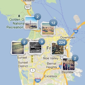
Pushed out to iPhone first and then Android, the new update has location in mind. With around 80 million users snapping and sharing worldwide, Instagram now wants users to be able to see their timeline on a map. Geolocation will allow your uploaded photos to be pinned to a map, allowing you and others to see where your ‘vintage’ pics were taken.
The Photo Map option overlays your pictures on a Google Maps map so you can see all the places you’ve Instagrammed in the world, if the regular thumbnail gallery is too boring for your liking.
Asides from Photo Maps, there are a few other neat tweaks that generally make the app much nicer to use. When viewing a user’s uploads in timeline view, scrolling is now continuous – eliminating the need to wait for more images to load. Caption editing is now multi-line for those who like to leave lengthy comments, and the photo uploading process is said to be more streamlined and easy.
Due to Twitter closing down its API for Instagram recently, the ‘Find Friends’ feature for finding nearby users has been removed from the newest version.
Existing images can be changed to appear on your Photo Map to get you started, and further updates can be geotagged to be added to your map going forward.
Instagram 3.0 is available as an update or new app install on iOS and Android from the App Store and Play Store respectively.
Let us know your thoughts on our comments below or via our @Gadget_Helpline Twitter page or Official Facebook group.


