Despite being a little bit borderline creepy, Google Maps is actually a pretty impressive bit of kit and it’s not just for providing very detailed and documented photographic tours of your neighbourhood to make it easy for stalkers to pinpoint your home on a the high tech map. Putting paranoia aside, Google Maps has also brought us incredible tours of some locations and landmarks many of us will never get the chance to see in person and global sights such as the Colosseum of Rome and the Château de Fontainebleau in France. Now Google is taking their innovative feature to new depths, allowing us a submerged tour of the world’s largest living organism, the Great Barrier Reef.

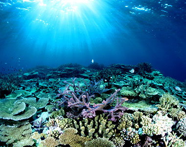
Partnering up with the University in Queensland Australia, Google Maps is set to submerge its users in the Asia-Pacific ocean to experience the awesome sight of the Barrier Reef – a naturally formed underwater wonder which spans across a 344,400 square kilometre area of seabed.
The Great Barrier Reef and another like it in Bermuda will be photographed in co-operation with insurance company the Caitlin Group who fund the Seaview Survey and a deep sea robotic sub which will collect data from 30 and 100 metre depths and in full 360 degree panoramic view, allowing Google Maps users to enjoy an immersive and educational experience through the Google Maps Street View mode. As well as general internet users, Google intends for this study to be used in researching and protecting the fragile ecosystem of the reef.
This will no doubt be a massive task and the project will begin in September with a series of videos being made available to watch the progress through Google’s video site YouTube leading up to the Great Barrier Reef experience going live on Google Maps – from the comfort of your desktop, and without the silly snorkel.
Let us know your thoughts on our comments below or via our @Gadget_Helpline Twitter page or Official Facebook group.